GIS Datasets Australia
There are various web-hosted datasets that you can access to obtain a vast range of geospatial data for use in 12d Model. Here’s where to find Esri REST GIS databases for data in Australia, covering national, state, and local (council) levels.
National Level
- Geoscience Australia (GA) – GA provides access to a range of geospatial datasets covering geological, geographical, and thematic data. Look for their Geospatial Web Services for access to REST services.
- Website: Geoscience Australia
- Australian Bureau of Statistics (ABS) – The ABS offers geographic and demographic datasets through web services that can be used in GIS applications.
- Website: Australian Bureau of Statistics
State Level
Each state and territory in Australia maintains its own GIS data repositories. Here are the primary agencies:
- NSW Spatial Services – The New South Wales government provides access to spatial data through the Spatial Services portal.
- Website: NSW Spatial Services
- Victorian Government Data Directory – Spatial data for Victoria can be accessed through the Victorian Government’s data directory.
- Website: Data.Vic
- Queensland Government Spatial Catalogue (QSpatial) – QSpatial offers a range of spatial and mapping data for Queensland.
- Website: data.qld
- Landgate – For Western Australia, Landgate provides various mapping and spatial data services.
- Website: Data.WA
- SA Government Data Directory – South Australia’s location and mapping data can be found on their government data directory.
- Website: Data.sa.gov.au
- Land Tasmania – Provides access to spatial data for Tasmania.
- Website: Land Tasmania
- Northern Territory Government – The NT Government offers spatial data through their website.
- Website: Northern Territory Government
- ACTmapi – The Australian Capital Territory’s GIS platform.
- Website: ACTmapi
Local Government Areas (LGA)
An example of an LGA dataset can be found here for Dubbo:
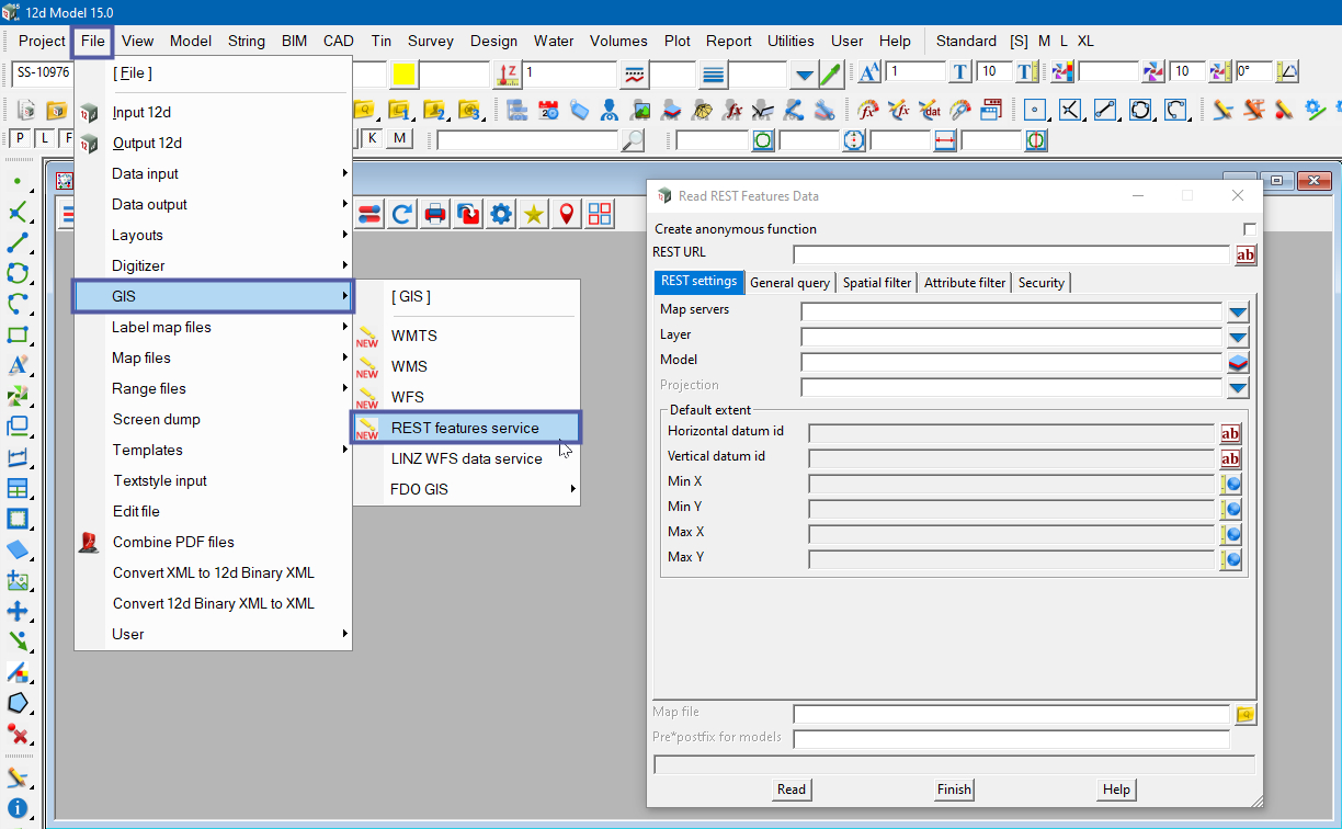
12d Model currently supports and has tools for WMTS, WMS, WFS, and REST feature service data.
Each of these data formats—WMTS, WMS, WFS, and REST Feature Service—serves different purposes and offers different capabilities for accessing and working with geographic data in GIS applications like 12d Model. Understanding their strengths and use cases can help users make informed decisions about which format best suits their needs when accessing external datasets.
REST Feature Service:
- What it does: A REST (Representational State Transfer) Feature Service is a type of web service that provides access to geographic features, similar to WFS. It follows the principles of RESTful architecture, which emphasizes statelessness, standard methods (like GET, POST, PUT, DELETE), and uniform resource identifiers (URIs) for accessing resources.
- How it works: Clients interact with the REST Feature Service using HTTP requests to perform operations such as querying, adding, updating, or deleting features.
- Use cases: REST Feature Services are commonly used for accessing and managing geographic data over the web. They provide a flexible and interoperable way to work with geographic features in web-based GIS applications.
WMTS (Web Map Tile Service)
- What it does:
A Web Map Tile Service (WMTS) is a type of web service that provides access to pre-rendered map tiles. These tiles are typically organised in a grid pattern and served over the internet. WMTS follows the principles of tiled web maps, which improve the performance and scalability of map rendering by serving fixed-size tiles instead of dynamically rendering the entire map. - How it works:
Clients interact with the WMTS using HTTP requests to retrieve map tiles. These requests specify the desired zoom level, tile coordinates, and the map layer. The server then responds with the appropriate map tiles, which can be seamlessly stitched together by the client to create a complete map view. - Use cases:
WMTS is commonly used for delivering map data in web-based GIS applications. It provides an efficient and scalable way to display large maps and is often utilised in applications that require fast and responsive map rendering, such as online mapping services, navigation systems, and location-based services.
WFS (Web Feature Service)
- What it does: WFS is a standard protocol for serving geographic features (such as points, lines, and polygons) over the internet as vector data. Unlike WMS, which serves images, WFS serves actual geographic data that can be manipulated and analysed.
- How it works: The client sends a request to the server for specific geographic features within a bounding box or based on other parameters. The server then sends back the requested features in a standard format like GeoJSON or GML.
- Use cases: WFS is useful for accessing raw geographic data for analysis, editing, or integration into GIS projects. It allows users to retrieve specific features or datasets for further processing.
WMS (Web Map Service)
- What it does: WMS is another standard protocol for serving map images over the internet, but unlike WMTS, it generates the images dynamically in response to client requests.
- How it works: When a client requests a map image for a specific area and parameters, the server dynamically generates the image and sends it back to the client.
- Use cases: WMS is often used for overlaying thematic data layers, such as weather data, demographic information, or land use data, on top of base maps.
To locate the the GIS tools in 12d Model, use:
File => GIS
